

Mapping Medieval History with Broken Pots
Mapping ceramic sherds can help to explore medieval history and wide-ranging exchange networks in the Mediterranean and beyond.
This blog post was originally featured on the Leiden Medievalists Blog.
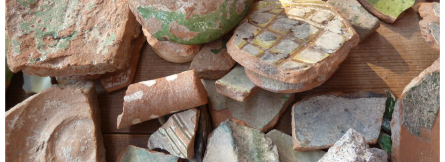
Broken pots
In recent years the traditional view of the medieval Mediterranean as a time of contraction and disintegration of the former Roman Empire on the one hand and of rapid expansion and flourishing of the Islamic Empire on the other has been replaced by a much more complex picture.
Yet, from a 21-first century globalised perspective it is still not easy to imagine that the economic reality and cultural horizon of ordinary people in the medieval world was anything more than quite limited, even if it becomes ever more evident that trade relations and cultural exchanges could be multi-layered and far-reaching. A burning question for scholars is how to pinpoint and visualise these networks on the basis of hard data. Well, archaeology can provide an answer in the form of one of the hardest data available: fragments of broken pots.
Here, I will illustrate how ceramics, not only one of the hardest but certainly one of the most mobile material products of the past, can help to explore medieval history and medieval exchange networks. Ceramic data from excavations and surveys enable the reconstruction of local, regional, interregional and long-distance exchange systems of all sorts of wares (ranging from luxury tableware to coarse wares and transport vessels) across time and space. These data need not to be confined to pottery finds from sites on land, but may also include cargo material from recovered shipwrecks – specifically amphorae, the large ceramic containers which were used for the long-distance transport of agricultural goods (such as wine, oil, etc.).
In the end, all these broken pieces of pottery in the (eastern) Mediterranean offer a source of information on the basis of which we can develop a geospatial perspective ranging from micro-regional to (long-term) macro-regional levels in the production, circulation, and consumption of goods used both by the elites and the masses in the medieval world.
In the following, I will discuss five case-studies from the Mediterranean area; all based on well-dated and well-quantified pottery finds.[1] Each one will help to map medieval history in its full complexity, with a little help from broken pots.
Mapping on a micro-level
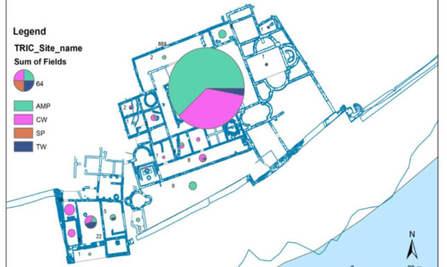
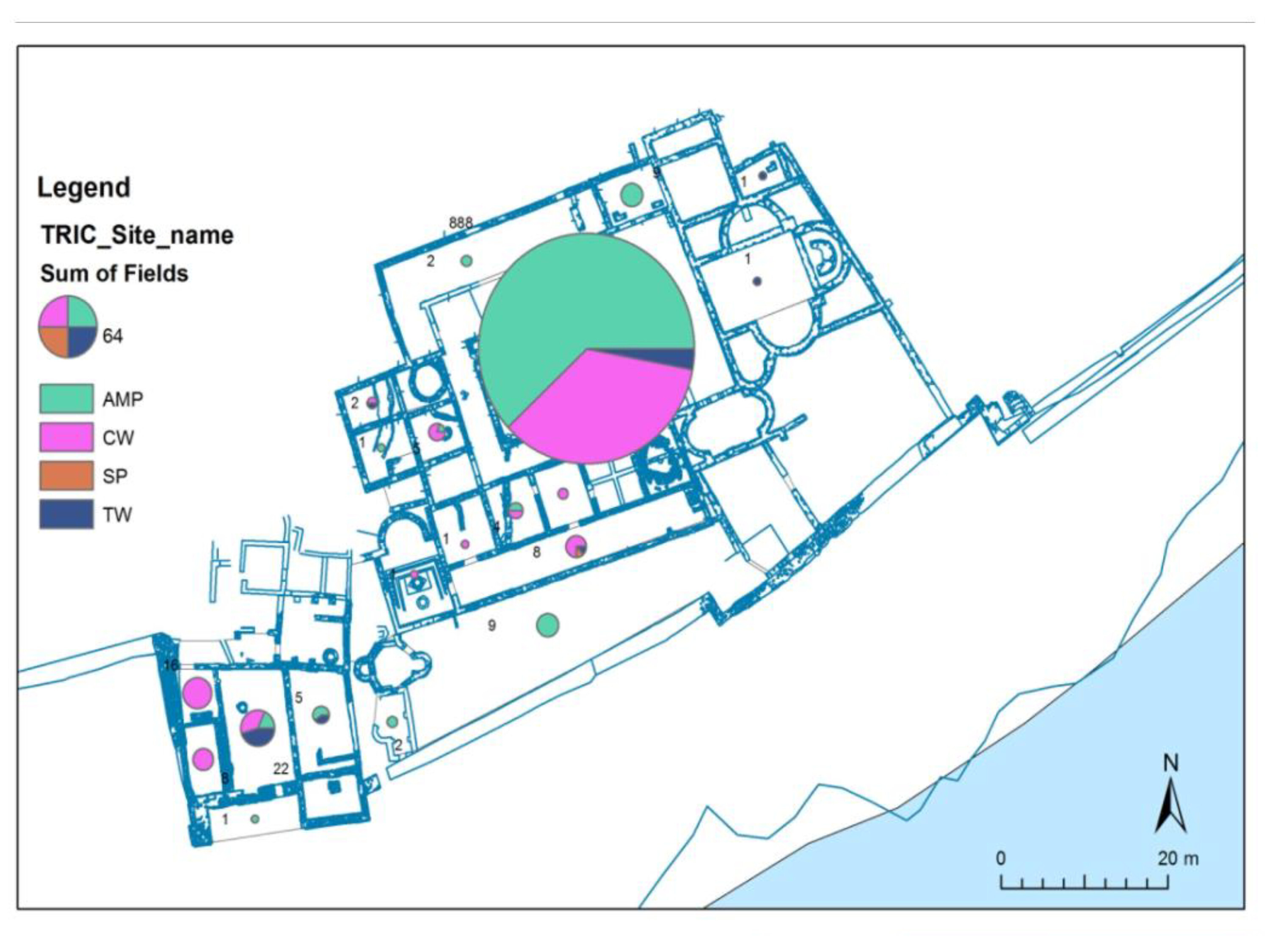
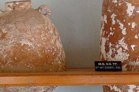
As the first case study, I will use the archaeological dataset of the coastal city of Butrint in southwestern Albania for mapping ceramics in the Mediterranean on a micro-level (for smaller community use). Butrint is a multi-period site located on a peninsula surrounded by the Vivari channel. Large-scale excavations yielded many thousands of medieval and post-medieval ceramic finds from various parts of the site: both on the peninsula as well as in the Vrina Plain across the channel. The sheer number of fragments enabled me to establish the long-term spatial distribution of the different wares and different pottery types on the site, and to understand the use and consumption of pottery in this settlement over various periods.
The data can be visualised in all sorts of maps, some of which are presented here. The first map shows the location and quantification of pottery per period on the peninsula and in the Vrina Plain at Butrint, ranging from Late Roman-Early Byzantine to Early Venetian times, that is to say: from the 5th/6th to the 16th century (Figure 1a).
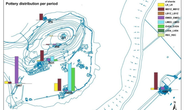
It is clear from these last two maps that the courtyard of the Triconch Palace yielded the most ceramic finds of the entire site, and in particular medieval amphorae. This is not the place to discuss this in-depth, it suffices to establish that these micro-level maps are not only useful for displaying the location and the number of artefacts on a site as a whole, but that they can also highlight the precise locations on a site where ceramics with specific characteristics in terms of shape, chronology, function, and provenance were recovered.
Mapping exports and imports on an intermediate level
The next two case studies show the mapping of ceramics in the Mediterranean on an intermediate level. The first map visualizes the wider commercial contacts of ceramic products made at the important harbour town of Chalcis on Euboea island in central Greece. It shows the distribution of Byzantine glazed tableware exported from Chalcis and to what extent these found their way from a potter’s workshop in this city to various regions in the Byzantine Empire through maritime routes (Figure 2). More specifically, the map illustrates finds of one particular glazed tableware group made in the Chalcis workshop, which is known as ‘Incised Sgraffito Ware’.
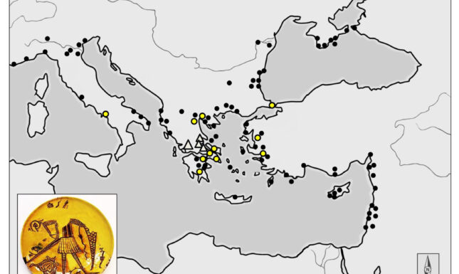
It is clear from the map that this pottery type from Chalcis was mostly distributed as an export product in the Aegean area and the Black Sea area, and in lower quantities with a more or less even dispersal in the western Mediterranean, all the way to sites in southern France. The distribution pattern also shows a remarkable cluster of this late 12th-/early 13th-century tableware in the Near East, specifically in the Crusader States in modern Syria, Israel, and Palestine. Furthermore, it becomes clear that Incised Sgraffito Ware from Chalcis with a distinctive warrior motif (shown in yellow dots on this map) was particularly distributed to sites in the western and eastern Aegean.
Another example of mapping ceramics on an intermediate level shows the distribution of imported medieval wares discovered during excavations in Ephesus in western Turkey (Figure 3). This map shows the diversity and range of ceramic imports to one site between the 13th and 16th centuries. The circulation of ceramics in this period is mostly regional, concentrated around Constantinople/present-day Istanbul and the Aegean (shown by a red circle). Apart from this regional Aegean connection, it is also clear that there were long-distance contacts in this period, with imported wares coming from Spain, Italy, Syria, and even from faraway places such as China. This underlines that an international-orientated pottery trade took off already in the latest phase of the Late Byzantine period (especially after the loss by the Byzantines of Acre in the Near East in AD 1291). This far-reaching international trade network, extending from the western Mediterranean to the Far East, is also a testimony of the level of affluence in Ephesus during the 14th and early 15th centuries.

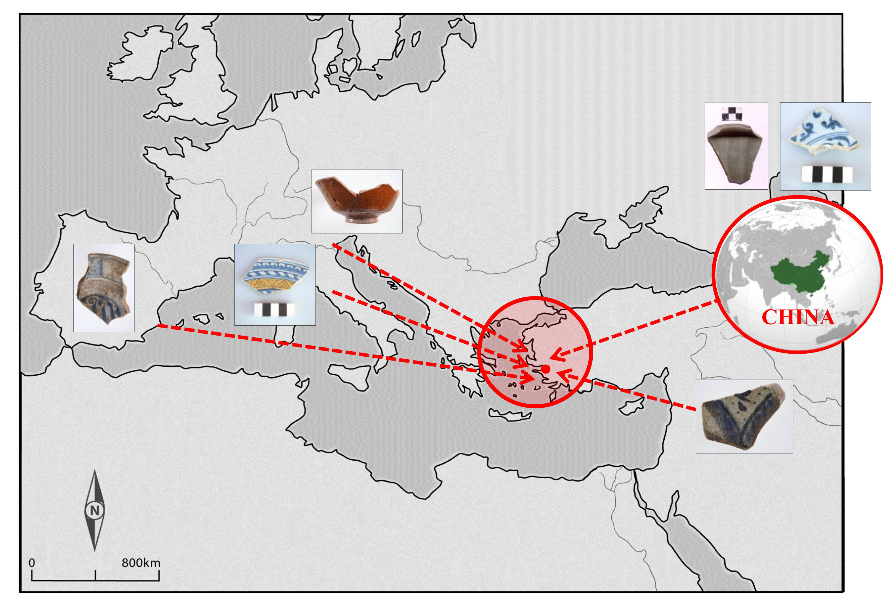
The further dissemination of these wares (and other merchandise) throughout the Mediterranean can probably be linked to larger international maritime trade routes (mostly carried out by the maritime city-states of Venice and Genoa), as well as to a regional diffusion of these export products through intermediate ports by private initiatives (for example, by individual Italian merchants or tradesmen from Italy and Spain).
Mapping on a macro-level
For mapping pottery on a macro-level, one may zoom out and follow Mediterranean ceramics on the move to more eastern regions. Regarding exported Byzantine ceramics, the easternmost examples have so far been found in India, often together with large numbers of contemporary gold, bronze and copper coins. Late Roman amphorae, for instance, such as the Late Roman amphora 1 (LRA 1) from the eastern Mediterranean (from Cilicia and/or Cyprus) for wine transport, arrived in India between the late 4th and early 7th centuries. So far, these transport jars have been found on coastal and inland sites in the Gujarat and Maharashtra regions, as well as at sites in southern India and Sri Lanka (Figure 4).
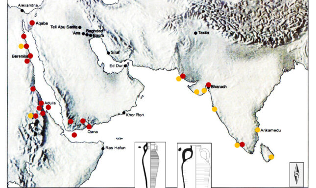
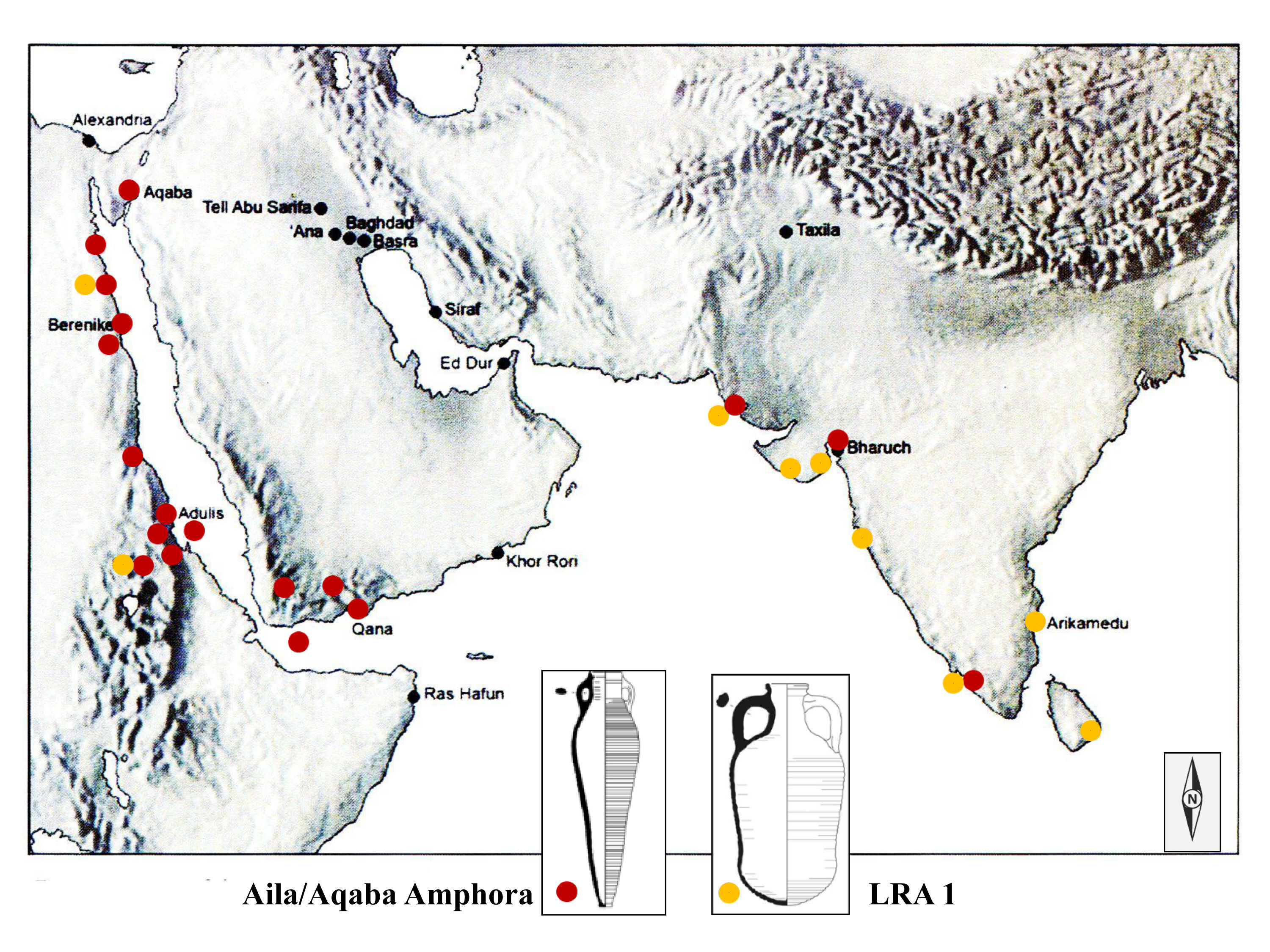
It is noteworthy that the LRA 1 often arrived in India together with other contemporary ceramic containers, among which the ‘Aila/Aqaba amphora’, originated from kilns in the northern Red Sea coastal port of Aqaba (in Jordan). These finds suggest the existence of a significant network, which took advantage of the Indian Ocean exchange system from the 3rd to the 8th centuries. The content of the Aila/Aqaba amphora is still unknown, although wine, garum (fermented fish sauce), dates, and other agricultural products have been suggested. It is, in any case, clear that mapping amphorae not only enables the identification of primary and secondary consumption and/or distribution centres, but also offers an idea about the volume and character of the imported agricultural products and the scale of the commercial transactions.
Mapping on a global level
The final case study concerns the mapping of ceramics on a global level (Figure 5). This map shows the worldwide distribution of Abbasid Lustreware, produced in the Abbasid Caliphate (more or less centred in modern-day Iraq) and generally dated to the 9th and 10th centuries. During the rule of the Abbasid Caliphs (750-1258), long-distance contacts with India and China intensified in the 9th century through the Persian Gulf. Subsequently, Chinese imports stimulated the manufacture of Early Islamic glazed tablewares, which were probably locally produced at the port city of Basra in southern Iraq following fashions deriving from China.
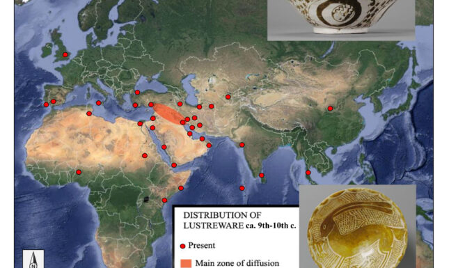
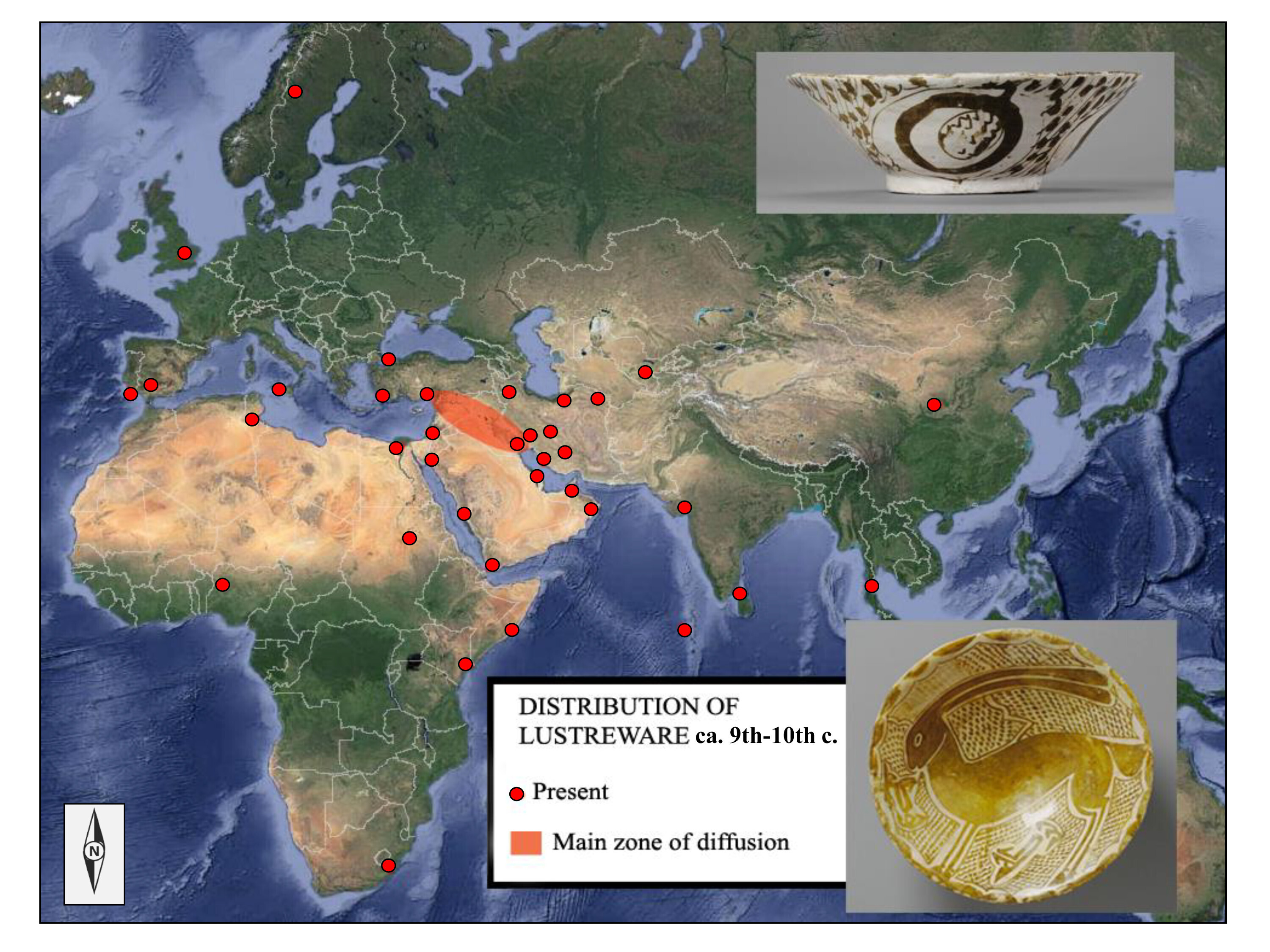
The extent of this East-West trade is specifically illustrated by the wide distribution of one group of glazed ceramics made during the Abbasid Caliphate: the so-called Lustreware. This Early Islamic tableware with metallic-looking painted designs in copper- and silver-rich pigments was eventually distributed over large parts of the then-known world. The pottery found its way from principal ports in the Persian Gulf (including Basra and Siraf) to sites in the Mediterranean, Egypt, Yemen, Sri Lanka, Thailand, the east African coast, and possibly even South Africa. Hence, Iraqi Lustreware was the global medieval ceramic product par excellence in ‘global’ exchange systems.
Conclusion
The presented case-studies show the potential of mapping medieval ceramics from the micro- to macro-level as a way to use data on daily-life objects to shed light on economic and commercial networks and developments in the Mediterranean and beyond. Mapping pottery allows for visualizing the distribution of artefacts over places and time, thus making their geographical and chronological distribution in a generalized way immediately perceptible in easy to comprehend overviews.
The crucial basis for mapping is of course the critical execution of archaeological fundamentals: the ceramic finds must be correctly classified and their chronology correctly determined. Only then do we start to see the geographic distribution of pottery types during the different periods of Mediterranean history or Indian Ocean trade, but also start to discern medieval trade routes/networks as well as start to identify contact zones between various cultural and political areas.
Although network visualization and plotting pottery data is certainly not free of methodological pitfalls, problems and limitations, the mapping of ceramic finds offers many opportunities for archaeologists and historians alike. Indeed, thanks to the hard fragments of broken pottery, archaeological data (in particular well-dated and well-quantified ceramics) speak much clearer and much more durable than any theoretical concept of networks in medieval times.
Further reading
Bağcι, Y. 2017. Coloured Ceramics of the Caliphs. A new look at the Abbasid pottery finds from the old Gözlükule excavations at Tarsus, Unpublished PhD Thesis, Leiden University.
Bağcı, Y. and J. Vroom 2017. Dining habits at Tarsus in the Early Islamic period: A ceramic perspective from Turkey, in: J. Vroom, Y. Waksman and R. van Oosten (eds.), Medieval MasterChef: Archaeological and Historical Perspectives on Eastern Cuisine and Western Foodways (Medieval and Post-Medieval Mediterranean Archaeology Series II), Turnhout: Brepols Publishers, 63-94.
Vroom, J. 2018. On the Edge: Butrint on the Western frontier of the Byzantine Empire, in: B. Düring and T. Stek (eds.), The Archaeology of Imperial Landscapes: A Comparative Study of Empires in the Ancient Near East and Mediterranean World, Cambridge: Cambridge University Press, 272-298.
Vroom, J. 2019. Medieval Ephesus as a production and consumption centre, in: S. Ladstätter and P. Magdalino (eds.), Ephesus from Late Antiquity to the Later Middle Ages. Proceedings of the International Conference at the Research Center for Anatolian Civilizations, Koç University, Istanbul, 30th November-2nd December 2012 (Österreichishes Archäologisches Institut Band 58), Vienna: Österreichisches Archäologisches Institut, 231-253.
Vroom, J. 2021a. Thinking of Linking: Pottery connections, Southern Adriatic, Butrint and beyond, in: M. Skoblar (ed.), Byzantium, Venice and the Medieval Adriatic. Spheres of Maritime Power and Influence, c. 700-1543, Cambridge: Cambridge University Press, 45-82.
Vroom, J. 2021b. From Xi’an to Birka and back: Constantinople as a nodal point in long-distance contacts during the Early Middle Ages, in: H. Nol (ed.), Riches Beyond the Horizon: Long Distance Trade in Early Medieval Landscapes (Medieval and Post-Medieval Mediterranean Archaeology Series IV), Turnhout: Brepols, 149-200.
Vroom, J. 2022. Shifting Byzantine networks: New light on Chalcis (Euripos/Negroponte) as a centre of production and trade in Greece, in: E. Fiori and M. Trizio (eds.), The 24th International Congress of Byzantine Studies, Volume 1: Proceedings of the Plenary Sessions, Venice: Edizioni Ca’Foscari, 453-487.
[1] I would like to thank my partners in Butrint (Prof. R. Hodges, Albanian Institute of Archaeology in Tirana), Chalcis (Ephorate of Antiquities of Euboea), Ephesus (ÖAI, Dr S. Ladstätter, Dr M. Steskal) and Tarsus (Dr A. Özyar, Dr Y. Bağcι) for their collaboration. See the linked webpages for more information on these projects.
© Joanita Vroom and Leiden Medievalists Blog, 2023. Unauthorised use and/or duplication of this material without express and written permission from this site’s author and/or owner is strictly prohibited. Excerpts and links may be used, provided that full and clear credit is given to Joanita Vroom and Leiden Medievalists Blog with appropriate and specific direction to the original content.


0 Comments